|
Issued: 0900 Friday 23rd June 2017
Duty forecaster: Simon Keeling
Unsettled with rain, showers and cooler weather next week
Say goodbye to the summery weather of the last week or so because things are about to become more unsettled. Low pressure takes control next week with showers or longer spells of rain on most days. Turning cooler later in the week as a northerly airflow becomes established. Summer will return again, but we'll have to wait a few days more.
 For the weather for the next few days click here For the weather for the next few days click here
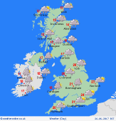
Monday 26/6/17
An area of low pressure passing over Ireland on Monday. This brings rain, some of it heavy over much of Ireland and Scotland together with western England and Wales. Drier and brighter in much of England with some decent spells of sunshine in the southeast. Rain edges into the west later, then spreading eastwards. Highs at 14 to 23C.
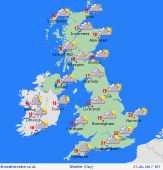 Tuesday 27/6/17 Tuesday 27/6/17
One area of low pressure is expected northeast of Scotland on Tuesday and will be bringing rain with it as well as some strong winds. Brighter skies with scattered showers in England and Wales, although another area of low pressure moves into Ireland giving rain here. Tops of 15 to 22C.
 Wednesday 28/6/17 Wednesday 28/6/17
An area of low pressure is going to be centred over the UK on Wednesday. This brings an unsettled day with rain and showers for many. Some of the showers could be heavy and thundery at times. Highs at 14 to 21C.
Thursday 29/6/17
Low pressure remains close by through Thursday. There will be further rain and showers for many. The showers may be heavy and thundery at times. Highs at 12 to 20C in strong northwest winds for many.
Friday 30/6/17
Low pressure drifts east on Friday. This introduces a chillier northerly airflow and brings showers with it. The showers heavy at times with a risk of thunder. Highs at 11 to 19C.
Saturday 1/7/17
Conditions may improve for Saturday with less in the way of showers and some sunny spells. The best sunshine is likely in the west. Highs at 13 to 21C.
|
