|
Issued: 0530hrs Saturday 7th October 2017
Duty forecaster: Garry Nicholson
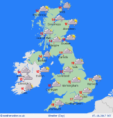 Rain or drizzle locally persistent in west Rain or drizzle locally persistent in west
Good morning,
A westerly airflow affects the British Isles, with low pressure focused over southern Scandinavia. High pressure stretches from the Azores into Biscay and France.
A weak frontal zone influences southern Britain & Ireland, bringing cloud and patchy rain, most persistent for south-west England, perhaps south Wales. A brisk westerly breeze, strongest around coasts in the south & east.
A few showers for northern regions, which may merge into persistent rain at times, some local heavier bursts possible. Showers will move east through the day, and some of these reaching East Anglia into the afternoon.
The north-east of England and east of Scotland should fare best, staying dry most or all day, with a little sun breaking through.
Cool at just 11 to 14C in the north-west, around 15C north-east, up to a high of 17C in southern counties, but cooler where rain lingers.
Have a great day.
Garry
|
