|
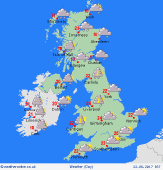 Wednesday Wednesday
Showery bursts of rain across northern England and eastern Scotland on Wednesday morning. The rain will be slowly edging eastwards with an odd heavier burst here and there. Brighter and drier weather to the west and south, although some drizzle and cloud may linger over the hills of central and southern Scotland and Pennines until early afternoon. Becoming brighter from the west as the day progresses with sunny spells developing and most places being dry, although an odd shower in possible in Ireland. Highs at 18C in northern Scotland, 24C in southeast England.
 Wednesday Night Wednesday Night
Becoming dry through the night for almost all areas with some clear skies developing. Always more cloud affecting western coasts and hills and it may be that this produces a few showers in Ireland and the west of Scotland later in the night. Lowest temperatures will be at around 9 to 14C.
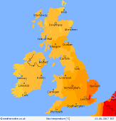
 Thursday Thursday
Low pressure centred to the northwest of Ireland on Thursday with fronts associated with it bringing rain through Ireland and western Scotland. In eastern Ireland and for most of England, Wales and eastern Scotland the day will be brighter with sunny spells. Western coasts and hills will always be prone to some low cloud and drizzle from time to time. Highs at 16C in western Ireland, 24C in southeast England.
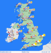 Friday Friday
High pressure may be to the east of the UK on Friday with low pressure to the west. There is a risk of some thundery outbreaks of rain in Ireland and this may affect southwest England too. Western Scotland could see a few showers, although most other parts of the UK should be dry with some sunny spells. A risk of thunderstorms in the far south of England ater. Highs at a muggy 25C in southeast England but more generally 19 to 23C.
|
