|
Issued: 0530hrs Monday 5 June 2017
Duty forecaster: John Ejdowski
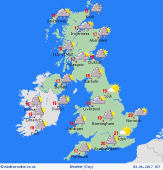 With a deepening area of low pressure to the south west tracking up into central England, the unsettled spell is going to continue and last into much of this coming week. Spells of moderate to heavy rain in the north and the west will sweep into most parts of Britain in the afternoon as the winds become strong from the south south west. These will reach gale force in the channel and around the southern coastal counties of England. Expect highs of 13 to 19 Celsius. With a deepening area of low pressure to the south west tracking up into central England, the unsettled spell is going to continue and last into much of this coming week. Spells of moderate to heavy rain in the north and the west will sweep into most parts of Britain in the afternoon as the winds become strong from the south south west. These will reach gale force in the channel and around the southern coastal counties of England. Expect highs of 13 to 19 Celsius.
This evening and tonight the strong cyclonic winds will affect mainly the southern half of England and Wales with gusts of 40-45 mph and 50 mph over high ground. The rain looks to clear from Wales and south west England in the evening and becomes confined to Scotland and eastern England overnight with a few showers in the west. Expect minimum temperatures of 9 to 12 Celsius.
If you are heading abroad much of Europe is looking warmer but unsettled with the best weather across Iberia.
Be Sure to Check out the Weatheronline Week Ahead Forecast for More Information Weather across the United Kingdom for the Next Seven Days. Have a Good Day.
Simon
Email me at [email protected]
|
