|
Issued: 1000hrs Sunday 10th December 2017
Duty forecaster: Garry Nicholson
Hard frosts toward the weekend
A very cold start to the new week, but a gradual lift in temperatures will take place into midweek, and some rain will spread from the west. However, colder air will quickly return from the north-west. Unsettled during Wednesday and Thursday, with a risk of gales. Snow is possible in the north & west later in the week.
For the weather for the next few days click here
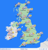 Wednesday 13/12/17 Wednesday 13/12/17
Fronts spread from the west bringing a spell of rain to most places early in the day. Slightly milder air briefly moves across the country, although cold air returns from the north-west through the day. Heavy showers in the west and north-west will spread increasingly eastwards. Sudden squally winds, hail and isolated thunder for Scotland & N.Ireland. Snow falling to increasingly low levels. Highs 1 to 7C, mildest far south.
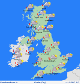 Thursday 14/12/17 Thursday 14/12/17
Detail is uncertain, but a small area of low pressure is expected to pass eastwards, bringing a period of rain to most places, turning to snow on the back edge of this system. Clusters of snow and hail showers will follow from the north-west. Blustery winds, risk gale force for a time. Temperatures 1 to 6C.
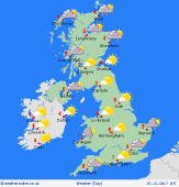 Friday 15/12/17 Friday 15/12/17
A chilly north or north-westerly pattern. Areas of wintry showers, focused around coasts in the west and north, perhaps also eastern areas. Sunny spells in central and southern regions. Frosty overnight where sheltered. Highs 1 to 5C.
Saturday 16/12/17
Pressure is likely to build from the west. A few scattered snow showers. A good deal of bright sunshine. Widespread hard frost is likely. Highs 0 to 4C.
Sunday 17/12/17
High pressure is expected to be nearby, bringing bright but frosty conditions. Some rain or snow may affect the north-west. Highs 0 to 4C.
Monday 18/12/17
A transition to milder south-westerlies. Frost in the south. Winds freshening in the north, with rain preceded by snow in the north-west. Highs 1 to 6C.
|
