|
Issued: 0840 Saturday 8 October 2017
Duty forecaster: John Ejdowski
Little rain in south, often windy
The weather looks unsettled to start this week with low pressure in control. Temperatures will be around normal. Around mid week high pressure is expected to build in across Britain giving dry, sunnier conditions. Temperatures appear to increase, becoming very mild.
For the weather for the next few days click here
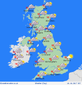
Tuesday 10/10/17
Cooler and becoming increasingly breezy through the day. Rain is expected across many areas in the morning, brighter and drier for the afternoon. Rain may affect much of Britain in the night and quite windy. Expect highs of 11 to 15C.
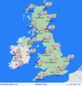
 Wednesday 11/10/17 Wednesday 11/10/17
Windy with rain persisting in the west and west and scattered showers in central, southern areas. Dry in the main across the east. A cloudy night across England and Wales with a risk of rain. Drier in the north. Expect highs of 11 to 17C.
 Thursday 12/10/17 Thursday 12/10/17
Today temperatures will be above normal. Quite a windy day in the north. Misty and murky with some drizzle in the west, sunnier towards the east. Little change to come overnight. Look for highs of 13 to 19C.
 Friday 13/10/17 Friday 13/10/17
Perhaps quite warm and windy in the north and the west. Much of England looks dry and mostly sunny. Cloudier across Scotland with drizzly rain in the west. Outbreaks of rain and drizzle affect much of the country overnight. Expect highs of 16 to 21C.
Saturday 14/10/17
Outbreaks of rain may affect Northern Ireland and western Scotland and windy here. England, Wales and southern Scotland appear dry with sunny spells. Staying on the warm side with above normal temperatures. Expect highs of 16 to 21C.
Sunday 15/10/17
It continues mild but turning cooler from the north later in the day. A band of rain clears Scotland and spreads south into England and Wales with showers in the north west. A colder night with a risk of frost in rural areas. Look for highs of 15 to 20C.
|
