|
Issued: 1000hrs Thursday 3rd August 2017
Duty forecaster: Garry Nicholson
Becoming drier in south; still mixed north & west
A changeable weather pattern continues over the weekend and into early next week, with bright spells mixed with rain at times. A spell of persistent rain is likely to affect parts of Britain into Monday. Toward midweek, showers should slowly fade as pressure builds from the south-west.
For the weather for the next few days click here
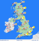 Sunday 06/08/17 Sunday 06/08/17
A ridge of high pressure influences much of Britain, bringing a fair day for many places, with sunshine best across the south & east. Fronts appraoching from the Atlantic bring thickening cloud to the west & north-west, and a threat of rain developing for Ireland, spreading to Scotland and areas near the Irish Sea later. Winds fairly light, but freshening south-westerlies in the west. Highs 18 to 23C, warmest south-east.
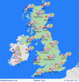 Monday 07/08/17 Monday 07/08/17
A shallow area of low pressure pushes across the country, and fronts are expected to become slow-moving. This brings a risk of persistent rain for many hours for central, western & northern England & Wales. Showery for Ireland & Scotland. Very little rain may reach the south-east, where some hazy sun is possible. Winds fairly light. Highs 16 to 22C, coolest where rain lingers.
 Tuesday 08/08/17 Tuesday 08/08/17
A west to north-westerly pattern is likely, with a freshening breeze. Showers are expected, these forming into bands across central & eastern districts, giving locally frequent rain, with some heavy and thundery downpours possible. Becoming brighter for the west & south-west as pressure builds, with scattered showers and sunny spells. Highs 17 to 22C.
Wednesday 09/08/17
Pressure is likely to build from the south-west, allowing conditions to settle for many places. Good spells of sunshine, and feeling warmer. A few showers may break out inland across eastern England by afternoon, but these very hit and miss. A west or north-westerly breeze. Highs 18 to 23C.
Thursday 10/08/17
High pressure most likely extends across southern regions, giving a fair and warm day. A risk of fronts returning from the Atlantic toward the north-west of Britain & Ireland, bringing cloud and patchy rain. A west or south-westerly breeze. Highs 18 to 24C.
Friday 11/08/17
Confidence of detail is low. Fronts across the north & west may bring outbreaks of rain, whilst high pressure toward the south should keep central & southern Britain dry and bright. Warm in the south-east. Highs 17 to 25C.
|
