|
Issued: 1100 Sunday 4 June 2017
Duty forecaster: John Ejdowski
Temperatures increasing for a time
With the jet stream running just to the south of Britain, it will develop fairly deep Atlantic low pressure areas to the west of Ireland. The lows and associated weather fronts will often bring in spells of heavy rain and gusty winds which will reach gale force through the Irish Sea. Temperatures will be near normal but become above normal later in the week.
For the weather for the next few days click here
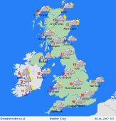
Wednesday 07/06/17
After a windy start across the north, the winds lessen while strong winds come in across England and Wales later. Most places will have a dry, bright morning with some sunshine. Outbreaks of moderate to heavy rain spread into Northern Ireland, Wales and south west England in the afternoon. Very windy in the evening with coastal gales in the south west. Very wet too across Britain and the rain lingers well into the night. Expect high of 12 to 19C.
 Thursday 08/06/17 Thursday 08/06/17
For Wales and central and southern parts of England further rain is expected throughout much of the day and here it will be very windy. Lots of showers, some heavy are forecast to the north. Rain clears by evening with showers in the north and the west. Expect highs of 13 to 20C.
 Friday 09/06/17 Friday 09/06/17
Perhaps the best day of the week. Many areas will be fair, warmer and dry but a few showers may affect the northern hills of England and Scotland. Rain sweeps into Wales and south west England in the evening and this spreads into all parts over night as gales run up through the Irish Sea affecting western coasts. Look for highs of 17 to 23C.
 Saturday 10/06/17 Saturday 10/06/17
Generally a cloudy, windy day across Britain with outbreaks of rain. Gales are possible across Ireland through the Irish Sea, across western Scotland and near the coast of Cumbria and Wales with gusts to 60 mph. A drier evening and night with showers in the north and the west and it stays very windy. Expect highs of 15 to 25C.
Sunday 11/06/17
It continues unsettled and windy across the country today with a good deal of cloud, a few sunny spells and a number of blustery showers. As these develop they become heavier for the afternoon. Gales are possible across Scotland and Northern Ireland. Most of the showers fade around mid evening. Highs of 14 to 20C.
Monday 12/06/17
It becomes less windy through the day. Apart from occasional showers across Scotland and north east England, we may see high pressure build in to give a dry day with some sunshine for most of England, Wales and Northern Ireland. Expect highs of 13 to 19C.
|
