|
Issued: 1000hrs Monday 14th August 2017
Duty forecaster: Garry Nicholson
Becoming increasingly humid
A window of drier weather in the middle of this week will be short lived as heavy rain returns from the Atlantic by Wednesday night. A showery pattern will affect the country later in the week. The weekend stays mixed, with heavy rain possible as the remnants of a tropical storm originating in the Bahamas brings additional moisture. This may bring very warm and humid air to southern Britain.
For the weather for the next few days click here
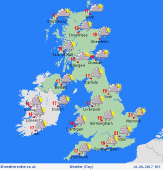
 Thursday 17/08/17 Thursday 17/08/17
Low pressure focused to the north-west of the British Isles produces unsettled weather once again by the end of the week. A spell of heavy rain is expected to clear eastwards early in the day, followed by a mix of sunny spells and heavy showers. Some frequent downpours are possible in the north & west, becoming more widespread elsewhere by the afternoon and evening. Gusty winds. Highs 16 to 23C.
 Friday 18/08/17 Friday 18/08/17
A generally unsettled day with low pressure in charge. Areas of rain or showers, some persistent and heavy bursts at times, spreading from the west. Some places toward the east may escape dry for a few hours. Limited sunshine. Blustery westerly winds. Feeling cool, top temperatures 15 to 21C.
 Saturday 19/08/17 Saturday 19/08/17
A westerly wind continues, bringing another day of showers, which may merge to give frequent rain locally, mainly west & northern regions. There should be drier periods in the east & south, with some sunshine breaking through. Pressure may build a little from the south-west. Breezy for all. Highs 16 to 22C.
Sunday 20/08/17
Low confidence in the forecast further ahead. A south-westerly pattern is likely. Rain spreading from the Atlantic may contain the remnants of tropical moisture, so has the potential to be heavy and prolonged for some. Away from the rain it will feel warm and humid. Highs 16 to 23C.
Monday 21/08/17
Pressure may build a little from the south, and fronts may shift slowly northwards. Risk of heavy rain in the west & north-west, but the south & south-east may see a dry and warm or very warm day. Highs 17 to 25C.
Tuesday 22/08/17
A hint of pressure building into midweek to give a drier picture for many. Some rain mainly toward the north-west. Feeling warm and humid. Highs 19 to 25C.
|
