|
Cold or very cold and wintry at first, less-cold later and with plenty of dry weather too
For the weather for the next few days click here
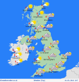
Sunday 18/3/18
Plenty of fine weather across more northern areas of the British Isles with plenty of sunshine too but after a very cold start. Cloudier across more southern and eastern areas of England with overnight snow flurries set to continue, at least for a time, through the day bringing some local accumulations, but these showers easing later in the day. All areas remaining cold with a fresh or strong E'ly wind bringing a marked wind-chill factor still across England and Wales, winds lighter further north. Highs 1C to 5C.
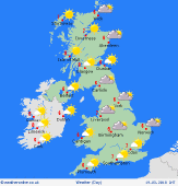
 Monday 19/3/18 Monday 19/3/18
Widespread harsh frost to start the day but, otherwise with the exception of a few wintry flurries in the south a lot of dry and sunny weather is expected, especially across northern areas of the British Isles. Winds still E'ly moderate or fresh across the south, with a pronounced wind-chill factor here still, elsewhere though winds lighter and not feeling quite as cold as previous days given plenty of March sunshine. Frost returning overnight. Highs 2C to 6C.
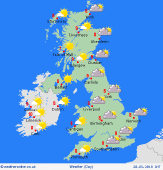
 Tuesday 20/3/18 Tuesday 20/3/18
Fine weather is expected to continue into next Tuesday at the moment as high pressure remains a dominant feature. A few light showers may develop across SE England, while some patchy light rain or drizzle may develop across N Scotland late in the day, otherwise emphasis is on a lot of fine weather with sunny spells, but still quite cold, especially early and late in the day with frost, but pleasant enough through the middle of the day in the March sunshine. Highs 3C to 8C.
 Wednesday 21/3/18 Wednesday 21/3/18
Some uncertainties by next Wednesday but with perhaps some cloudier, windier and damp weather developing across parts of northern and western areas of Scotland through the day. Elsewhere though it is likely that high pressure will still be the dominant feature bringing mainly dry weather with some bright or sunny spells, but with generally more cloud around than previous days. Windy in the north, winds still light and variable further south. Overnight frost possible, but, overall, it will continue to become milder. Highs 5C to 10C.
Thursday 22/3/18
Increasingly unsettled weather is forecast at the moment across more northern and western areas of the British Isles as weather fronts move in off the Atlantic to bring some rain and showers, perhaps with a fresh or strong W or SW'ly wind too. High pressure will be declining into France by this point but may well still influence the weather across most of England and Wales, especially central and southern areas, with further dry and, overall, bright weather. Mild, highs 6C to 11C.
Friday 23/3/18
Unsettled across most areas by next Friday as things stand, but especially in the north and west where it may well be quite wet and windy through the day. Perhaps still drier and brighter further south and east, but even here some rain or showers may well develop as the day progresses. Average temperatures. Highs 7C to 12C.
|
